- Date
- April 20, 2021, 20:52 local (Apr 21, 2021, 01:52 UTC)
- Place
- Brownsville, TN
- Injuries
- 2 fatal
- Damage
- Destroyed
- Phase of flight
- Enroute
- Aircraft
- N4303GPiper PA-28RT-201T
- Defining event
- Enroute-descent: VFR encounter with IMC
- Weather
- Instrument (IMC) · Night
- Status
- Completed
- Report
- Approved by Office Director
- Investigation class
- Class 3
- NTSB office
- Eastern Region Aviation
- Parties
- FAA/ FSDO, Piper Aircraft Company
- FAA report
- 20210420005429A
- Case key
- 102954
From the NTSB’s public API. By law, NTSB reports can’t be used as evidence in lawsuits over the accident.
On this page
Probable cause
The student pilot’s continued visual flight rules flight into night instrument meteorological conditions, which resulted in spatial disorientation and a rapid uncontrolled descent into terrain. Contributing to the accident were the self-induced and external pressures that likely influenced the pilot’s decision to both initiate and continue the flight.
Findings · 7
NTSB’s coded findings. Those marked are part of the probable cause; the rest are factors or other findings. Under each, the cases with the same finding.
Sequence of events
The events NTSB coded, in order, by phase of flight. The defining event is the one that best describes the accident. Under each, the cases with the same event anywhere in their sequence.
Analysis
The flight instructor and student pilot discussed a solo cross-country flight the morning of the accident so that the student could see his father, who had been recently hospitalized unexpectedly. The instructor provided the required solo cross-country route endorsement for the flight and expected that the pilot would depart early in the afternoon to avoid night and instrument meteorological conditions (IMC) moving into the destination area; however, the pilot departed several hours later, which resulted in much of the flight being conducted in night conditions. The pilot was receiving visual flight rules (VFR) flight following services from air traffic control at the time of the accident. As the pilot prepared to begin a descent from cruise altitude to the destination airport, he was advised by air traffic control of instrument flight rules (IFR) conditions immediately ahead and along the remainder of his route, and was told to maintain VFR. The controller provided alternate VFR airports and suggested a course to maintain VFR. The pilot acknowledged the information and advised that he would deviate to remain clear of the weather; however, flight track and weather information revealed that, about this time, the airplane likely entered IMC conditions, which included precipitation and clouds in addition to light to moderate turbulence. Shortly after entering the IFR conditions, the airplane entered a descending, tightening, rapidly accelerating spiral that continued until impact. The spiral was indicative of a pilot experiencing the effects of spatial disorientation, and the airplane reached an airspeed significantly greater than its never-exceed speed. Before entering the spiraling descent, the flight was cruising below the freezing level, which made the risk of airframe icing minimal. Examination of the airplane revealed no evidence of preimpact mechanical malfunctions or failures, and in addition, the propeller displayed multiple signatures that were indicative of an engine operating at high power. Review of the forecast conditions was consistent with the weather conditions encountered during the accident flight. Review of hourly observation weather data revealed that, had the pilot departed earlier in the afternoon as was expected from his flight instructor, the flight likely would have been completed in day VFR conditions. The pilot did not receive a weather briefing before departure, and what, if any, weather information the pilot reviewed before departing could not be determined. The pilot’s logbook showed that he had experience flying the accident route of flight in his past dual and solo flight training. The logbook entry for the previous solo flight contained a remark that the pilot diverted due to weather; however, that flight was conducted during daylight and the accident flight had self-induced and external pressures that likely affected the pilot’s desire to complete the flight. Toxicology testing revealed evidence of the pilot’s useof multiple potentially impairing substances, but no blood levels were available; therefore, whether the pilot was experiencing any effects from his use of these substances could not be determined. However, given the circumstances surrounding the accident, it is unlikely that effects from his use of these substances contributed to this accident.
Factual narrative
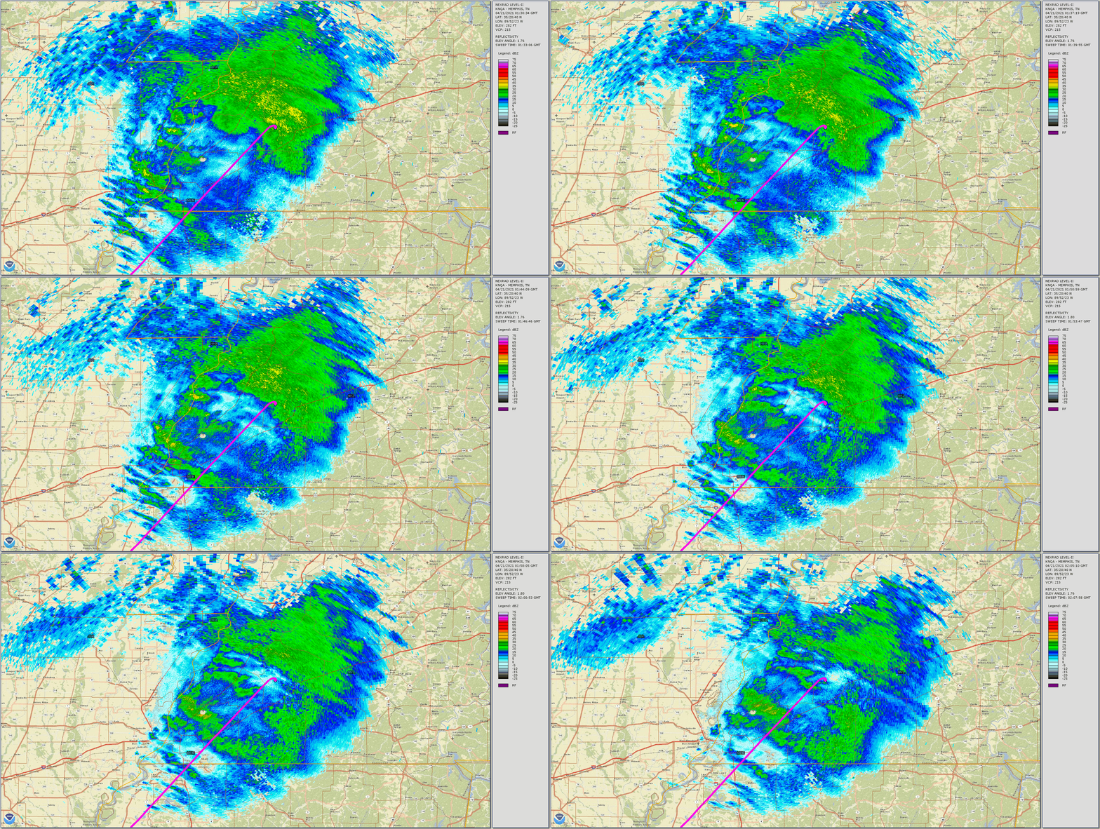
Review of the pilot’s ForeFlight account found that, on the day of the accident several routes of flight were entered from LVJ to CEY, with an intermediate destination of LBX (Texas Gulf Coast Regional Airport, Angleton, Texas). Routes were entered between the early morning hours of 0100 and 0130 the day of the accident. At 1703, the route LVJ-LBX-CEY with an enroute altitude of 8,000 ft was entered. The last two route entries were entered at 1806 and 1808, which was after departure. The routes had dropped LBX and contained only LVJ-CEY at an altitude of 8,000 ft, which was generally consistent with the ADS-B flight track. A mechanic at the departure airport reported that, about 1100 the day of the accident, he had a brief discussion with the pilot during which the pilot stated that he planned to depart about 1300; however, he recalled that the pilot taxied from his hangar closer to 1700, and the mechanic observed one passenger onboard. The pilot’s flight instructor believed that the pilot departed with full fuel tanks and according to a fuel receipt, the pilot received 9.9 gallons at 1106 the morning of the accident. The instructor reported that he was aware that the pilot’s purpose of flight was to travel to visit his father who had been recently hospitalized. The instructor reported that he asked the pilot three times before the flight, “do you need me to go with you?” The pilot declined the offers. A family member confirmed that one purpose of the flight was to visit the pilot’s father who had been recently hospitalized. In addition, the pilot’s mother (the passenger) needed to arrive at the destination airport on the day of the accident due to her meeting another family member for a planned vacation. The family member confirmed that the pilot planned to depart no later than 1400; however, his iPad was not connecting to the internet, and he was at the cellular carrier until about 1645 to resolve the issue. According to the family member, at this time, the passenger’s sister insisted that they make it there by Tuesday and the pilot expressed that “he could make a detoured route where the weather was not as bad.” According to the FAA Aviation Instructor’s Handbook (FAA-H-8083-9), Chapter 1: Risk Management and Single-Pilot Resource Management, it states in part: Identifying Risk Hazards and their associated risks can either be obvious or harder to detect. You should methodically identify and classify risks to a proposed or ongoing flight by maintaining constant situational awareness. To assist this process, it is helpful to apply the simple acronym PAVE to your risk management process. The acronym stands for Pilot, Aircraft, Environment, External pressures. The Handbook further states in part: E = External Pressures External pressures are influences external to the flight that create a sense of pressure to complete a flight—often at the expense of safety. Factors that can be external pressures include the following: Someone waiting at theairport for the flight’s arrival. A passenger the pilot does not want to disappoint. The desire to demonstrate pilot qualifications. The desire to impress someone. (Probably the two most dangerous words in aviation are “Watch this!”) The desire to satisfy a specific personal goal (“get-home-itis,” “get-there-itis,” and “let’s-go-itis"). The pilot’s general goal-completion orientation. Emotional pressure associated with acknowledging that skill and experience levels may be lower than a pilot would like them to be. Pride can be a powerful external factor! According to FAA registration records, the pilot purchased the accident airplane in July 2019. A mechanic reported that he performed a routine annual inspection on the airplane in April 2021; however, the airplane’s maintenance records were not recovered during the investigation. According to the Airplane Flight Manual, Section 2 Limitations, VNE was 193 knots indicated airspeed, or 186 KCAS. On April 20, 2021, at 2052 central daylight time, a Piper PA-28RT-201T airplane, N4303G, was destroyed when it was involved in an accident near Brownsville, Tennessee. The student pilot and passenger were fatally injured. The airplane was operated as a Title 14 Code of Federal Regulations Part 91 personal flight. According to the student pilot’s flight instructor, he and the student met mid-morning to discuss a solo cross-country flight from Pearland Regional Airport (LVJ), Houston, Texas, to Kyle-Oakley Field Airport (CEY), Murray, Kentucky. The student told the instructor that he needed to visit his father, who had recently been admitted to the hospital. The flight instructor stated that “it was supposed to be a daytime flight,” expecting the student to depart no later than 1300 or 1400 due to the weather coming in later in the evening. Review of Federal Aviation Administration (FAA) automatic dependent surveillance – broadcast (ADS-B) data found that the student pilot departed LVJ at 1720, proceeded southbound for a few minutes, then northeast on an en route course that was generally consistent with a direct route of flight to CEY for about 3 hours and 30 minutes at altitudes between about 7,000 ft mean sea level (msl) to 9,000 ft msl. The course showed little deviation until the final 2 minutes of flight. Review of air traffic control communications provided by the FAA revealed that in the final few minutes of the flight, the pilot was communicating with Memphis Air Route Traffic Control Center (Memphis Center) while receiving visual flight rules (VFR) flight-following services. About 2 minutes and 30 seconds prior to radar contact being lost, the pilot stated to the controller that he was flying at 7,500 ft msl, his destination was CEY, and added that he was planning to “start my descent now” and he was going to make it a “gradual descent.” The controller responded by providing the CEY altimeter setting and advised the pilot of moderate precipitation “starting now lasting all the way to the[destination] airport.” The controller further stated, in part, that “everything between now and [CEY] is on the verge of being i f r [instrument flight rule] conditions. It looks likes ceilings are down around about 1,500 ft most everywhere.” The pilot responded, “ok affirmative I’m gonna still descend down” to “2,000 3,000 feet to have plenty of clearance for anything that’s not updated on my screen if that’s ok and until I get within 10 miles I’ll drop to my final descent.” The controller responded by advising the pilot to maintain VFR and provided an additional weather observation report for an airport along the route of flight that was reporting IFR conditions. The controller advised that a course to the east may help him remain clear of the weather and advised that McKellar-Sipes Regional Airport (MKL) was still reporting clear skies. The pilot acknowledged the controller and said he would fly east to stay out of the weather. The controller responded by providing one additional airport reporting VFR conditions that was about 20 miles south of his destination, which the pilot acknowledged. About 35 seconds later, a “mayday” call was announced over the radio. There was no call sign associated with the distress call, nor any further information given with the call. The controller attempted to reach the pilot several times after the mayday call; however, no further communications were received. Figure 1 provides an overview of the final minutes of the ADS-B flight track overlaid with paraphrased controller-pilot communications. Figure 1. End of flight ADS-B data with controller-pilot communication paraphrased. N4303G is the accident airplane and ‘ZME’ is Memphis Center. A National Transportation Safety Board (NTSB) performance study reviewed the final few minutes of ADS-B data and found that a descent was initiated at 2051:50. In the subsequent 20 seconds, the airplane slowed from 160 knots calibrated airspeed (KCAS) to 120 KCAS and entered a right turn. The descent then rapidly accelerated, airspeed rapidly increased, and the right turn tightened into a descending spiral. At 2052:29, the airplane exceeded its never-exceed speed (VNE) of 185 KCAS in the descent, and about 10-15 seconds later, the airplane reached a maximum recorded speed of about 270 KCAS. The final data point was at 2052:46; the airplane was at an altitude of 1,450 ft msl, flying south-southwest about 165 KCAS. The wreckage was located about 1,000 ft from the final reported position at an elevation of about 300 ft msl. Figure 2 provides an overview of this calculated performance information based upon ADS-B data. Figure 2. End of flight altitude (msl) and calculated groundspeed and calibrated airspeed. The FAA issued a missing aircraft alert shortly after radar contact was lost. Local authorities discovered the wreckage about 0730 the next morning. According to the autopsy performed by the West Tennessee Regional Forensic Center, Office of the Medical Examiner, the cause ofdeath was multiple blunt force traumatic injuries, and the manner of death was accident. The examination was significantly limited by the degree of injury; no significant natural disease was identified. Toxicology testing performed by the FAA’s Forensic Sciences Laboratory identified ethanol, methanol, alprazolam, bupropion, buspirone, dihydrocodeine, metoprolol, atorvastatin, and amlodipine in kidney tissue. Most of these were also identified in muscle tissue. No blood was available for testing. Ethanol is primarily a social drug with a powerful central nervous system depressant. Ethanol may also be produced in tissues after death by microbial activity. Methanol is another form of alcohol that can be produced in tissues after death. Alprazolam is a sedating benzodiazepine commonly marketed with the name Xanax. Bupropion is an antidepressant commonly marketed with the name Wellbutrin. It can have a number of potentially impairing psychoactive effects. Buspirone is a sedating anti-anxiety medication often marketed with the name Buspar. Dihydrocodeine is an opioid analgesic often used in preparations for the treatment of cough. It is also a metabolite of hydrocodone, a Schedule II controlled substance. Metoprolol and amlodipine are blood pressure medications and are not generally considered impairing. Atorvastatin is an anti-cholesterol agent commonly marketed with the name Lipitor. It is not generally considered impairing. A cold front had moved across the area hours prior to the accident, and a low- and mid-level trough was located above the accident site at the accident time, helping to bring clouds and precipitation to the region. Cloud ceilings at the accident site were indicated by a high-resolution rapid refresh sounding from 1,200 ft above ground level (agl) with reduced visibility due to mist, with cloud tops indicated near 13,500 ft msl based on satellite information. Review of METARs for airports near the accident site supported this satellite and sounding information. The freezing level was near 7,500 ft mean sea level. In addition, strong northerly wind gusting to 24 knots at the surface through 14,000 ft msl was observed. Review of data from the nearest weather surveillance radar station revealed that airplane’s flight track in the final few minutes of flight approached an area of light precipitation. Figure 3 shows the airplane’s flight track, precipitation, and the accident site. Figure 3. Overview of the flight track and weather surveillance radar data near the time of the accident AIRMET advisories Tango and Zulu were valid for the area at the accident time. The AIRMETs warned of moderate turbulence between 8,000 and 16,000 ft msl and moderate icing between the freezing level and 18,000 ft msl. The nearest TAF to the accident site was McKellar-Sipes Regional Airport (MKL), located 23 miles east of the accident site. About the time of the accident, the TAF called for wind from 340° at 17 knots with gusts to 28 knots, greater than6 miles visibility, moderate rain showers in the vicinity, broken ceiling at 2,500 ft agl, and overcast skies at 8,000 ft agl. Review of CEY METARs revealed that, at 2115, the airport was reporting marginal visual flight rule conditions (MVFR) with visibility of 3 statute miles (sm), scattered clouds at 900 ft agl, a broken ceiling at 1,300 ft agl, and overcast clouds at 5,500 ft agl. At 2135, the airport reported IFR conditions of 4 sm visibility, broken clouds at 700 ft agl and 1,300 ft agl, and overcast clouds at 3,500 ft agl. For the next several hours, the airport continued to report IFR conditions. At 2053, MKL reported 10 statute miles visibility, scattered clouds at 4,700 ft agl, broken clouds at 8,000 ft agl, and overcast clouds at 9,500 ft agl. According to Leidos Flight Service and Foreflight, there was no record that the pilot filed a flight plan or requested a weather briefing via telephone or online. Review of METARs and TAFs nearby and at the destination airport found that day VFR conditions prevailed throughout the afternoon and early evening. According to FAA airman records, the pilot was issued a student pilot certificate on August 4, 2019. He was issued a third-class medical certificate on January 14, 2019, which had expired on January 31, 2021. The flight instructor reported that the student told him that he had renewed his medical certificate in February 2021; however, the FAA had no record of such medical examination nor any record the pilot attempted to complete the FAA BasicMed Certification. Review of the pilot’s logbook found that his first flight was logged on December 5, 2018, and entries continued through October 4, 2020. The logbook showed that, in November 2019, the student completed two cross-country flights between LVJ and CEY. The first flight was a dual instructional flight and the second flight, later in the month, was a solo cross-country flight. A remark in the logbook for the solo flight stated, “cross-country to KCEY but set down KDYR/ Weather.” The flight instructor provided photocopies of a current 90-day solo endorsement and a cross-country route of flight endorsement for the accident flight that he had given the pilot. He added that he had no knowledge that the pilot planned to depart with a passenger. The instructor reported that the student had not attempted the private pilot aeronautical knowledge test prior to the accident. The wreckage was located partially submerged in a creek and along a muddy ravine in a forest. All major components of the airplane were located within about a 100-ft-long debris path, and the wreckage was heavily fragmented. There was no evidence of a postimpact fire. Flight control cable continuity could not be established from the flight control surfaces to the cockpit due to the heavy fragmentation of the wreckage. The control cables that were observed displayed fracture features consistent with separation due to overload. The cockpit and instrument panel were heavilyfragmented. The standby attitude indicator was found in the debris. When disassembled, the gyro remained intact, and its housing exhibited rotational scoring. No other flight instruments, including the primary flight display, were observed or readable. The engine displayed significant impact damage; however, examination and teardown revealed no evidence of preimpact mechanical malfunctions. The propeller flange and propeller hub had separated from the engine and were located within a few feet of the main wreckage. Partial s-bending, leading edge gouges, and chord wise scratches were observed on the propeller.
Aircraft
- Registration
- N4303G
- Reported as
- Piper PA-28RT-201T (NO SERIES)
- Category
- Airplane
- Serial number
- 28R-8331035
- Built
- 1983
- Engine
- Continental TSIO-360-FB, 201 horsepower, reciprocating
- Damage
- Destroyed
- Flight
- Personal · Part 91
- Airworthiness certificate
- Standard, Normal
- Last inspection
- Annual · April 1, 2021
- Departed
- LVJ · Houston, TX
- Destination
- CEY · Murray, KY
- Equipment
- Stall warning system, Electronic primary flight display, ADS-B
Matched to the registry by N-number and the event date; the registry’s history has gaps, so older matches can be wrong. Compare the reported make and model.
Flight crew
As NTSB recorded them. NTSB leaves out names.
- Role
- Student pilot
- Age
- 55
- Injuries
- Fatal
- Certificate
- Student
- Toxicology
- Performed
- Flight hours
- 135 total · 108 in this make and model · 51.2 as pilot in command · 3.1 in the last 90 days
Weather
- Conditions
- Instrument (IMC) · Night
- Wind
- 350° at 18 knots
- Visibility
- 5 statute miles
- Lowest ceiling
- 1,200 ft overcast
- Temperature
- 41 °F, dew point 39 °F
- Altimeter
- 30.11 inHg
- Icing
- Mixed
- Turbulence
- Moderate
- Observed at
- M04, 10 nm away
- METAR
- KM04 210155Z AUTO 35018KT 5SM BR OVC012 05/04 A3011 RMK A01
Docket · 23
The files NTSB released with the investigation on June 8, 2022, on NTSB’s docket system: statements, records, photos and specialists’ reports. 55.7 MB in all.
FAA reports on this event · 1
The FAA’s own accident and incident reports, matched to the aircraft by N-number and date.